
For general earthquake action steps — what to do in the first 10 seconds, intensity scale, hotel and subway procedures — see the Japan Earthquake Safety Guide. This post covers Okinawa-specific risks that do not apply to mainland Japan cities, and exactly what to do at each major tourist spot.
The event that defines Okinawa's tsunami risk
24 April 1771. The Great Yaeyama Tsunami (明和大津波).
An earthquake estimated at M7.4 to M8.0 struck near the Yaeyama Islands in the southern Ryukyu chain. The tsunami that followed produced waves estimated at up to 30 metres along some coastlines. Across the Ryukyu Islands — including Ishigaki-jima, Miyako-jima, and surrounding islands — approximately 13,000 people were killed. In some communities, close to half the local population died.
Most travellers who know Japan is seismically active think primarily of Tokyo, Osaka, or the Tohoku coast. Few realise that Okinawa and the Ryukyu Islands form a separate seismic zone sitting directly beside the Ryukyu Trench — and that the historical record here is severe.
Okinawa's three unique risks
Risk 1 — The Ryukyu Trench and extremely short tsunami warning times
The Ryukyu Trench (琉球海溝 / 南西諸島海溝) runs north to south roughly 100–200 kilometres east of Okinawa's main island. Okinawa sits between this trench and the East China Sea — a narrow island directly in the tsunami path.
| Location | Estimated tsunami arrival after a Ryukyu Trench earthquake |
|---|---|
| East coast of Okinawa main island | **5 to 15 minutes** |
| West coast (Naha, Kokusai-dori area) | approximately 20 to 30 minutes |
| Miyako-jima | approximately 5 to 10 minutes (closer to the trench) |
| Ishigaki-jima | approximately 5 to 10 minutes |
These arrival times are far shorter than anything faced in Osaka or Nagoya. If you are on the east coast of Okinawa and feel strong shaking, the shaking itself is your evacuation signal. Do not wait for an official warning before moving to high ground.
Risk 2 — You cannot escape the island
After a large earthquake in Tokyo or Osaka, heading inland or to higher ground in surrounding prefectures is an option. In Okinawa, you are on an island. When flights stop and ports close, every decision about where to go must be made within the island's geography.
The highest point on Okinawa's main island is approximately 498 metres. But the major tourist areas and central Naha sit well below 30 metres above sea level. In a tsunami event, vertical evacuation within the island — reaching ground of at least 30 metres elevation — is the only option.
Risk 3 — You may be in the water when it happens
Okinawa is one of Japan's premier destinations for snorkelling, diving, and beach resorts. Being in or near the sea when an earthquake and tsunami strike is a risk specific to Okinawa that simply does not apply in the same way to any major mainland city.
What to do at Okinawa's top tourist spots
🏯 Shuri Castle (首里城)
The symbol of the Ryukyu Kingdom, situated on a hill in Naha at approximately 120–130 metres above sea level. Parts of the castle are under reconstruction following the 2019 fire.
The good news: Shuri Castle's elevation puts it well above any realistic tsunami inundation zone. This is one of Okinawa's safest tourist sites from a tsunami perspective.
Still watch for:
- The castle walls are Ryukyu limestone (琉球石灰岩) — limestone blocks can dislodge and fall during shaking.
- Active reconstruction means scaffolding and temporary structures are present.
- Stairs and slopes throughout the grounds become hazardous during strong shaking.
What to do:
- Move away from stone walls and gates immediately — stand in open grass areas.
- Stay clear of any scaffolding or construction zones.
- Because Shuri Castle is already at high elevation, no further tsunami evacuation is necessary — stay at your current location once shaking stops.
🛍️ Kokusai-dori (国際通り)
Naha's main tourist strip — roughly 1.6 kilometres of shops, restaurants, and souvenir stores. It sits at approximately 10–20 metres above sea level.
The risks:
- Dense commercial buildings on both sides create a narrow corridor where glass facades, awnings, and signs fall into the street during shaking.
- Low elevation means tsunami inundation is possible in a major Ryukyu Trench event.
What to do:
- During shaking, move away from shop fronts and into the centre of the road. Do not stand under signs or awnings.
- If inside a shop, move away from shelving and display cases and head toward the exit.
- When a tsunami warning is issued, leave Kokusai-dori immediately. Head east toward Shuri (uphill, higher elevation) or northeast toward the Asato area. Do not go toward Naha Bus Terminal or Oroku Station — both are lower ground.
🐠 Churaumi Aquarium & Motobu Peninsula (美ら海水族館·本部半島)
Located on the western coast of the Motobu Peninsula in northern Okinawa. The aquarium sits directly beside the East China Sea on low coastal ground.
The risks:
- The aquarium's west-facing side opens directly onto the ocean. While the Ryukyu Trench is to the east, tsunami wave refraction means waves can reach the western coast too — with less warning than the east.
- Ocean Expo Park, surrounding the aquarium, is coastal flatland.
- The mountain road leading to the aquarium can be blocked by rockfall after a large earthquake.
What to do:
- Inside the aquarium: move away from the large viewing tanks (glass fracture risk), and follow staff toward emergency exits.
- When a tsunami warning is issued, move inland and uphill toward the centre of Motobu Peninsula (east direction). Do not follow coastal roads.
- If you have a vehicle, take National Route 449 inland — avoid coastal roads.
- If on foot, identify the nearest elevated hillside before you arrive — the peninsula has hills of 50 metres or more within walking distance of the aquarium.
🌊 Okinawa beaches and water sports
This is the highest-risk scenario specific to Okinawa — and the one most likely to catch travellers unprepared.
If you are snorkelling or swimming when an earthquake occurs:
- Strong shaking may be difficult to feel underwater.
- Watch for sudden changes in water clarity, unusual currents, or the sea surface dropping rapidly — these are tsunami precursor signs.
- Exit the water immediately at the first sign of any of these, or if you hear an alarm.
Warning signs that require immediate action (move to high ground if you observe any of these):
- The sea pulls back sharply and the seabed is exposed
- A loud roaring sound comes from offshore
- You feel strong shaking, even if you cannot see visible damage on shore
On the beach:
- At the first indication of earthquake shaking, stop swimming and get out of the water.
- Once on shore, move inland and uphill immediately. Do not stand on the beach watching the sea.
- Leave all belongings — bags, chairs, equipment — and move.
- Wearing a life vest or snorkel gear does not protect you from being caught in a tsunami surge. Distance from the water is the only protection.
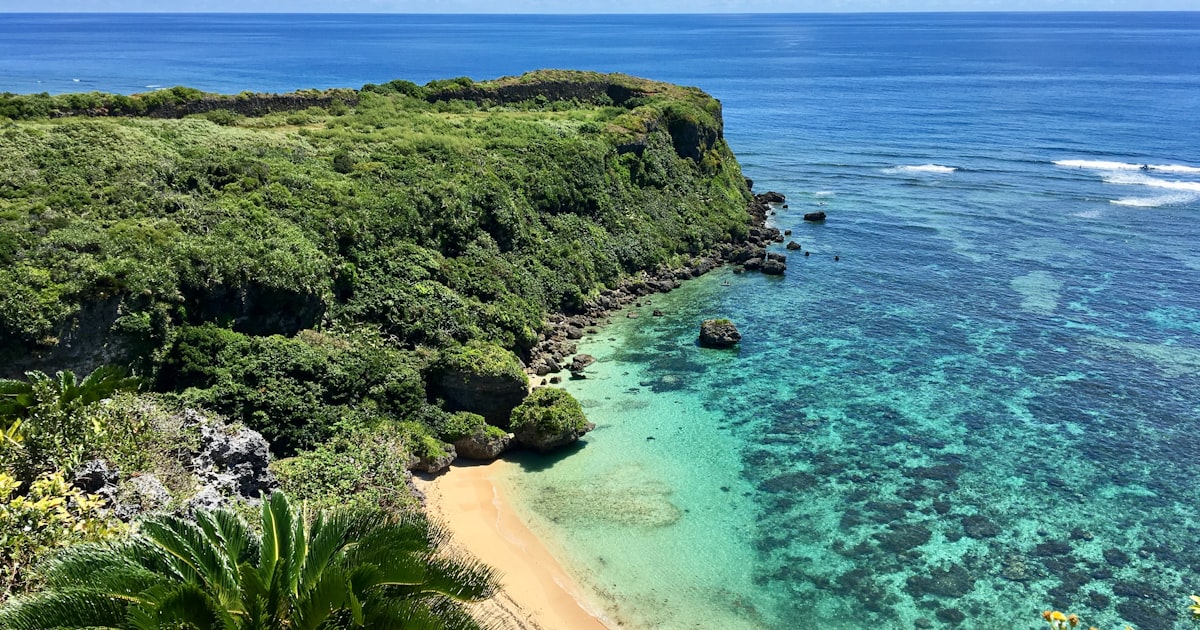
🌿 Manzamo Cliff (万座毛)
A distinctive coral limestone cliff on Okinawa's west coast, approximately 20 metres above sea level, with a grass-covered viewing area at the edge.
The risks:
- The cliff edge sits directly above the ocean. Ground vibration from a large earthquake can fracture coral limestone.
- At 20 metres, Manzamo is above average inundation risk, but not at the 30-metre threshold recommended for major Ryukyu Trench events.
What to do:
- Move at least 3 metres back from the cliff edge immediately during shaking.
- Once shaking stops, move further inland and to higher ground — 20 metres is not sufficient safety margin for a worst-case event.
- If you arrived by tour bus, stay with the group and follow the guide's instructions.
🏝️ Outer islands — Miyako-jima and Ishigaki-jima
The outer islands of Okinawa Prefecture are closer to the Ryukyu Trench than the main island, and have correspondingly shorter tsunami warning times.
- Miyako-jima and Ishigaki-jima may have as little as 5 to 10 minutes between an earthquake and the first wave.
- These islands have less total land area and fewer high-ground options than the main island.
- The Yaeyama Islands — where the 1771 tsunami was most devastating — are in this same region.
- On any outer island: treat strong shaking as an immediate evacuation signal without waiting for a siren.
Tsunami evacuation in Okinawa — practical guide
When a tsunami warning is issued for Okinawa, the key question is not which direction to run, but how high to get.
From Naha, the nearest high-ground evacuation areas:
- East toward Shuri (south-east) — over 100 metres elevation, approximately 3–4 kilometres on foot
- North-east toward Urasoe or Inamino — 50–80 metres elevation
Three rules specific to Okinawa:
Car evacuation is accepted — Okinawa's local government acknowledges that some distances to high ground are too far to walk. If you cannot reach safety on foot, drive toward high ground. But if traffic stops, abandon the vehicle and continue on foot immediately.
Look for the blue tsunami evacuation building signs — designated buildings (津波避難ビル, Tsunami Hinan Biru) are marked with a white background, blue wave symbol, and a figure of a person on stairs. These buildings are structurally rated to withstand tsunami force and can be used as vertical evacuation if no higher ground is reachable.
Do not descend after the first wave — subsequent waves in a tsunami sequence are often larger than the first. Stay at elevation until an official all-clear is broadcast. This will come via NHK World Radio Japan, the J-Alert system, or the JNTO Safety Tips app.
Before you go: quick checklist
- Before any beach or water activity, locate the nearest high-ground area (30 metres or above) on the map
- Check your accommodation's elevation — if below 20 metres, identify the nearest tsunami evacuation route
- Look for 津波避難ビル (Tsunami Hinan Biru) signs near your hotel or resort
- Save your country's embassy or consulate number before departure
- Download the JNTO Safety Tips app (multilingual tsunami and earthquake alerts)
- On outer islands (Miyako-jima, Ishigaki-jima): identify the island's high-ground areas before you arrive — warning time may be 5 minutes or less
Official resources
- JMA Tsunami Information (English) — jma.go.jp/bosai/map.html#5/26/128 (tsunami)
- Okinawa Prefecture Disaster Prevention — bousai.pref.okinawa.jp (tsunami evacuation maps)
- NHK World Radio Japan — 738 kHz AM / online stream (English-language emergency broadcasting)
- JNTO Tourist Helpline — 050-3816-2787 (24/7, multilingual)
Related guides